MT AMY PROJECT
Multiple Gold Targets
western australia
Overview
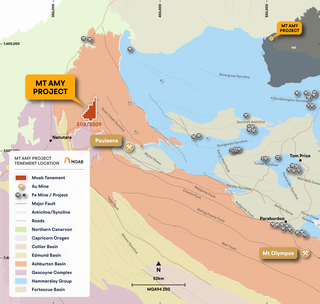
- Comprises a single exploration licence application (E08/3319) covering an area of 155.34km2 (49 graticular blocks).
- Located 1060km north of Perth and 107 km southeast of Onslow, in the Shire of Ashburton, Western Australia, and 43km northwest of the Paulsens Gold Mine (Northern Star Resources Ltd).
- Access from Perth is via the Great Northern Highway and North West Coastal Highway to the south of the tenement, then turning west on the Nanutarra Road.
- Gravel tracks provide access from the south and north of the tenure, and the Cane River runs east-west through the north of the property.
- A prominent 16km2 outcrop in the centre of the tenure forms Mt Amy, which has a peak at 364m RL.
Geology
A Tier-1 Location
- Located within the Ashburton Basin; a series of deformed Proterozoic metasedimentary and metavolcanic basins.
- The Ashburton basin is between the Pilbara and Yilgarn Cratons (Martin et al, 2005).
- Located at the north-western extent of the Nanjilgandy Fault, the same structural corridor that hosts the Paulsens and Mt Olympus
Gold Deposits. - Rocks within the project area are moderately well exposed.
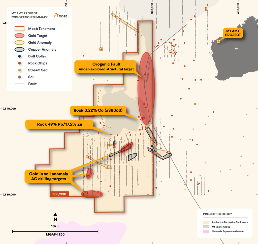
- A single sample (15297) from report A9698 (Otter Exploration) of gossan within a 1m wide quartz vein returned 49% Pb, 17% Zn and
0.22% Cu and the minerals galena, chalcocite, smithsonite and cerussite were noted. - Another sample (15280) from the same report, but without location details, returned assays of 3.7% Pb and 0.7% Zn (DMIRS, 2021).
Previous Exploration
Limited Historic Exploration
Historic exploration within the Mt Amy Project area has included aerial and ground geophysical surveys, mapping, rock, soil and stream
sampling, and vacuum drilling.
A database has been created for the Mt Amy project, based on data available from historic WAMEX reports, containing:
- 7 Drillholes – Vacuum <20m depth
- 142 Rock Samples
- 79 Stream Sediment Samples
- 5433 Soil Samples (including 3454 shallow vacuum samples <3m)
Historical Exploration
An Underexplored, High Potential Asset
Fortescue
- Completed airborne magnetics and radiometric surveys, along with a regional scale geophysical review (see report WAMEX report
a118598).
Sandfire Resource: 2005-2010
- Held the ground as part of their Urandy Project and completed airborne magnetic/radiometric survey and geochemical sampling
(rock/soil/stream sediments) (WAMEX reports a89072, a080441, a078844), which returned a robust +7ppb gold in soil anomaly to the
south of the Mt Amy massif.
Ashburton Minerals: 1997 – 1998
- Conducted stream sediment sampling during 1997/1998, with low level (0.3-1ppb Au) anomalism.
CRA Exploration: 1992 - 1993
- Explored the area with rock and soil sampling returned base metal anomalies associated with weak uranium anomalism.
Otter Exploration: 1981
- Explored for uranium in 1981 (WAMEX report a9698), and completed airborne spectrometer and ground scintillometer traversing with
no encouraging uranium results. - One rock sample from the southwest of Mt Amy returned very high-grade lead (49%), zinc (17.2%) and copper (0.22%) values from
“Gossan w. galena, smithsonite, cerussite and minor chalcocite”. - The location of this sample has been digitised from a map. However, field validation and further mapping/sampling is required to
understand the cause of this anomaly within a fold hinge.
Exploration Potential
Multiple Gold Targets
- A conceptual gold target in the Ashburton Basin, without any sub-surface exploration.
- Historic surface sampling has outlined multiple anomalous areas, including a robust 1800m x 450m 7ppb gold in soil target to the
southeast of the Mt Amy massif. However, significant areas of transported overburden are masking the underlying geology, which
may link areas of anomalism. - Historic rock sampling has returned significant base metal and gold assays, which have not been fully tested:
- The gossan/quartz vein sampled by Otter Exploration (49% Pb, 17.2% Zn and 0.22% Cu), and the rock samples by CRA
Exploration (up to 0.22% Co) need to be located, with mapping and further rock samples collected for verification of assays. - The 1800 x 450m gold soil anomaly has never been followed up.
- Rock samples up to 0.63 g/t Au associated with mylonitic quartz veins were followed up with shallow vertical vacuum drill
holes, which would not have been suitable for intersecting vertical quartz veins.
- The gossan/quartz vein sampled by Otter Exploration (49% Pb, 17.2% Zn and 0.22% Cu), and the rock samples by CRA