WOODLANDS PROJECT
Gold & Base Metals
Western australia
Overview
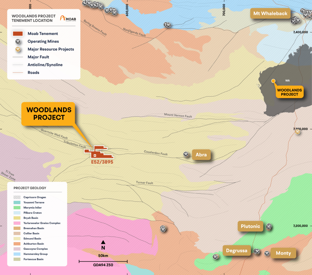
- Early stage greenfields project located in the Gascoyne Province of Western Australia.
- Consists of one exploration licence (E52/3895) that was granted in January 2021 and covers 193km2 (63 graticular blocks).
- Located 875km northeast of Perth, 245km southwest of Newman and 220km northwest of Meekathara.
- The Woodlands – Mt Augustus Rd passes through the north of the tenement.
- The tenement straddles the boundary of the Shire of Upper Gascoyne and the Shire of Meekatharra.
Geology
Abra Style Base-Metal Mineralisation
- Considered prospective for Abra style base-metal mineralisation1.
- The Woodlands Project is located in the Mesoproterozoic Edmund Basin, one of a series of sedimentary basins formed between the Archaean Yilgarn and Pilbara cratons.
- The stratigraphic sequence of coarse continental clastic sediments were deposited unconformably on the older Paleoproterozoic Ashburton and Blair Basin basement as alluvial fan and river channel deposits (Martin et al,2005).
- These sediments were overlain by finer sandstones, siltstones, shales, and carbonates of the Edmund Group and intruded by mafic sills. The entire basin is folded on east-west to west-northwestern axes.
Previous Exploration
Underexplored and Highly Prospective
- Historic exploration within the Woodlands area has included aerial and geophysical surveys, rock chip sampling and RAB, RC and diamond drilling.
- A database has been created for the project based upon data available from historic WAMEX reports, containing:
-
- 28 reverse circulation drill holes
-
- 3 diamond drill holes
-
- 4871 LAG samples (not all within lease boundary)
-
- 57 rock chip samples
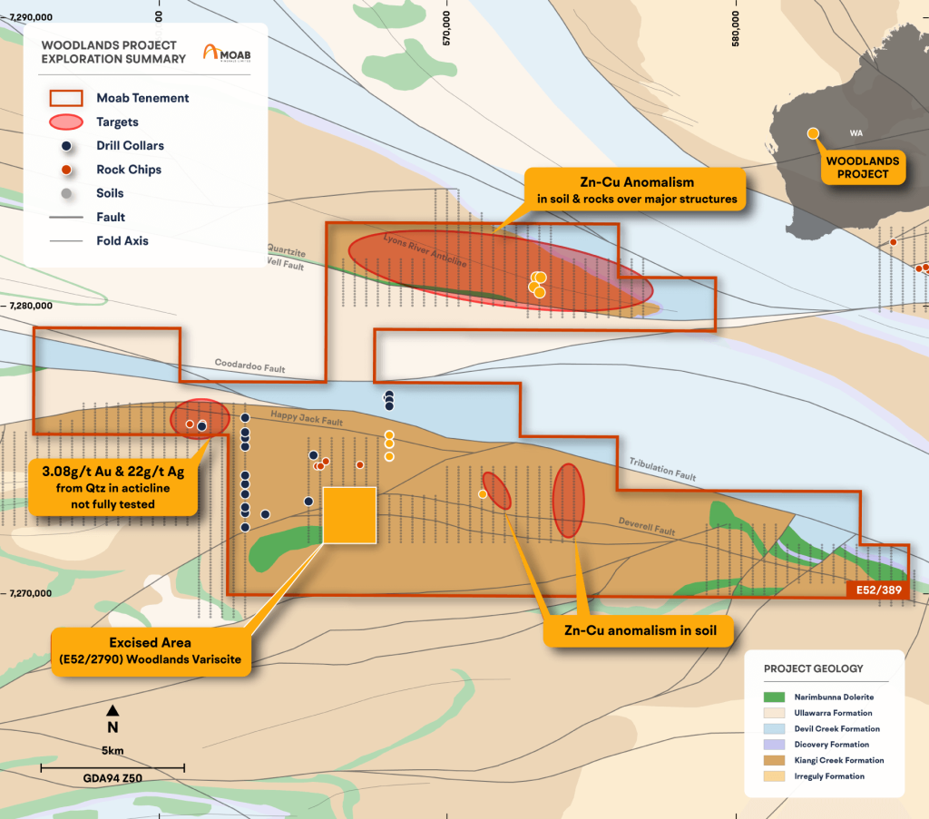
- Geopeko DDH to test outcropping quartz reef 3.08g/t Au and 22g/t Ag did not reach the target depth due to drilling problems–this prospect remains untested.
- Gold potential on-strike from variscite-gold prospect not followed up.
Historical Exploration
An Underexplored, High Potential Asset
Explaurum Ltd: 2014
- Reprocessed open-file geophysical data and field reconnaissance observed that mineralisation occurs as quartz-gossan breccia
structures and as stratiform carbonate/silica +sulphide replacement. - Mineralisation was predominantly Zn-Cu with minor Au-Pb (WAMEX report a104108).
BHP: 1994 - 1998
- Fieldwork in proximity to the Woodlands tenure at Wittenoom Bore.
Western Mining Corporation: 1992- 1994
- Explored the ground as part of the Munjang Project and conducted aerial magnetic survey, ground SIROTEM, gravity, magnetic and
IP surveys, lag sampling (3122 samples) and RC drilling (WAMEX report a39472). - Ten RC/D holes were drilled at Wittenoom Well West, testing Quartz Well fault intersection, with the best intercept being 18m @
1040g/t Zn, including 12m @ 290g/t Cu in oxide material. - At Wittenoom Well, 6 RC/D holes were drilled testing a magnetic/gravity anomaly. One diamond hole was drilled to 564m, through
the gravity anomaly, which intersected a 23cm bed of pyrrhotitic silty shale (390.9m) which assayed 0.08% Cu, 0.14% Zn, 0.14% Pb.
Geopeko: 1981 - 1994
- Explored for magnetite associated base metal sulphide mineralisation within Bangemall Group sediments, and gold saddle
reefs in structural traps (WAMEX report a13367). - Completed aerial photography studies, aerial magnetics survey, ground magnetics/gravity/SIROTEM surveys, rock chip
sampling, close spaced RAB over 4 geophysical targets, and 5 RC holes - The location of all sampling and drilling has been digitised from maps, so the confidence in accuracy is very low. Rock sampling
returned; anomalous copper within thin (<1m) bands associated with variscite, anomalous Zn/Ag at “Anomaly 1”, and anomalous
Au from quartz-sulphide within a fold hinge
Limited Historical Exploration
- Early explorers in the region recognized the prospective stratigraphy and identified gossans with highly anomalous Au, Ag, Pb, Zn values.
- RC and diamond drilling in the 1980/1990’s targeted geophysical anomalies akin to the Abra deposit, however many holes did not reach target depth, leaving the targets untested.
- Historic surface geochemical exploration has identified numerous zinc – copper targets within favourable stratigraphy, which have not been drill tested.
- In 1994, WMC made a corporate decision not to explore for Zn-Pb deposits and ceased work without testing many targets.